Welch-Dickey, April 22, 2006
Preview
 Our next scheduled hike is the Welch-Dickey loop. The loop is about 4.5 miles, it is a moderate hike
with several viewpoints. At the summit of Dickey Mountain the elevation is 2734 feet, the actual
elevation gain for the hike is 1800 feet. It is generally described as "a lot of view for a small
amount of hiking".
Our next scheduled hike is the Welch-Dickey loop. The loop is about 4.5 miles, it is a moderate hike
with several viewpoints. At the summit of Dickey Mountain the elevation is 2734 feet, the actual
elevation gain for the hike is 1800 feet. It is generally described as "a lot of view for a small
amount of hiking".
NEXT HIKE: April 22, Welch Dickey
MEETING SPOT: L.L. Beans in Concord at 9:00 (exit 14 off 93) or trailhead at 10:00
TRAILHEAD: From Exit 28 of I-93, take NH Route 49 NE about 5.9 miles, and turn left on Mad River Road.
(There is a sign but it may sneak up on you.) After 0.7 miles turn right on Orris Road, and after
another 0.6 miles turn right into parking lot.
HIKE LEADER: Mark Malnati
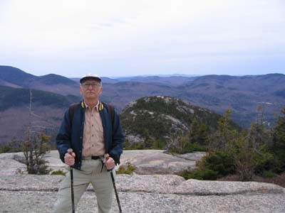
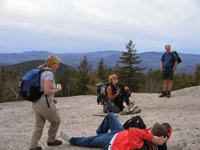 Welch-Dickey made for a nice #2 hike of the season. There were 15 two-legged hikers and 2 four-legged
hikers (Hannah and Midas), which made for a pretty good sized group. We first climbed up
Welch Mountain, which gave us some nice views of the Waterville Valley and the Tripyramids. We had
lunch at the top of Welch Mountain, then climbed down and up to Dickey Mountain. More great sights
along the way, the Franconia Notch was in view, Lincoln and Lafayette still had snow on top as did North
Kinsman.
Welch-Dickey made for a nice #2 hike of the season. There were 15 two-legged hikers and 2 four-legged
hikers (Hannah and Midas), which made for a pretty good sized group. We first climbed up
Welch Mountain, which gave us some nice views of the Waterville Valley and the Tripyramids. We had
lunch at the top of Welch Mountain, then climbed down and up to Dickey Mountain. More great sights
along the way, the Franconia Notch was in view, Lincoln and Lafayette still had snow on top as did North
Kinsman.
Heading down Dickey Mountain we enjoyed our last views of the hike, the ridge provided a great view of Welch Mountain and it is always a thrill to walk along a trail with such a drop off. It did not seem to bother Hannah or Midas, who walked over to the edge for a better view. The group went to Waterville Valley for ice cream, but its still too early, they were closed. Maybe Diane will have better luck on our third hike of the season.